Bomb Cyclone NSW – Floods, Winds and Outages Explained
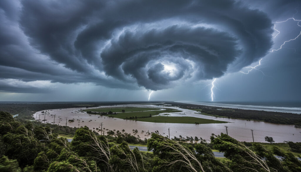
A rapidly intensifying bomb cyclone slammed eastern New South Wales in early July 2025, triggering widespread flash flooding, destructive winds exceeding 100 km/h, and mass power outages across the Mid North Coast to the South Coast. The system, which underwent explosive cyclogenesis north of the Tasman Sea, delivered concentrated rainfall totals exceeding 200 mm in 24 hours to parts of Sydney and surrounding regions, prompting thousands of emergency calls and significant travel disruptions.
The event represents a classic east coast low that met the technical criteria for bombogenesis—a pressure drop of at least 24 millibars within 24 hours—fueled by sea surface temperatures 2-4 degrees above average. Unlike tropical cyclones, this extratropical system formed through baroclinic instability, yet produced hurricane-like impacts across coastal communities.
Authorities continue to assess the full scope of damage as clean-up operations proceed, while meteorologists analyze the role of anomalous warm waters in driving the storm’s rapid intensification.
What Is a Bomb Cyclone?
Tasman Sea / NSW Coast
July 2-3, 2025
Explosive Cyclogenesis
Flash Flooding, Winds >100km/h
- Rapid pressure drop of 24+ millibars in 24 hours defines the system
- Formation differs fundamentally from tropical cyclones via baroclinic instability
- Warm Tasman Sea temperatures (2-4°C above average) fueled intensification
- Manifested as a rare east coast low with concentrated coastal rainfall
- Over 2,300 emergency calls logged overnight at peak intensity
- Ausgrid restored power to 46,000 premises following outages
- No fatalities reported despite extensive infrastructure damage
| Metric | Measurement |
|---|---|
| Pressure Drop | ≥24 hPa in 24 hours |
| Peak Wind Gusts | 113 km/h (70+ mph), locally >100 km/h |
| Maximum Rainfall | 200+ mm in 24 hours |
| General Rainfall | 127+ mm (5+ inches) |
| Sea Surface Anomaly | 2-4°C above average |
| Power Affected Initially | 30,000+ homes and businesses |
| Incidents Logged | 1,860+ (Hunter to South Coast) |
| Emergency Calls | 2,300+ overnight |
| Formation Type | East Coast Low / Extratropical |
Where and When Did the Bomb Cyclone Hit NSW?
Geographic Scope
The system developed rapidly north of the Tasman Sea before tracking directly into the NSW coast. Areas from the Mid North Coast through the Sydney Basin to the Far South Coast experienced the heaviest impacts, with the Illawarra and South Coast regions bearing significant rainfall and wind damage.
Timeline of Intensification
The low-pressure system began organizing in the Tasman Sea, drawing energy from unusually warm waters before undergoing bombogenesis as it approached land. Peak impacts concentrated on July 2, 2025, with the most intense rainfall and wind conditions affecting coastal communities through that evening and into July 3.
The bomb cyclone intensified rapidly north of the Tasman Sea, where sea surface temperatures registered 2-4 degrees Celsius above average, providing the thermal energy necessary for explosive cyclogenesis before the system tracked toward the coast.
What Damage and Impacts Has the Bomb Cyclone Caused in NSW?
Power Infrastructure and Property
Wind gusts exceeding 70 mph (113 km/h), with localized reports surpassing 100 km/h, toppled trees and power lines across the region. Ausgrid reported restoring power to 46,000 customers after the initial outage affected more than 30,000 homes and businesses. A demountable office block collapsed under wind pressure, while numerous roofs sustained damage from flying debris.
Transport Networks
Sydney Airport experienced hundreds of flight delays and cancellations as the storm peak disrupted operations. Road closures affected major routes throughout the Hunter, Sydney Metro, Illawarra, and South Coast regions, with flash flooding rendering bridges impassable and stranding vehicles in low-lying areas.
Emergency Response Statistics
State Emergency Service crews responded to over 1,860 incidents ranging from flood rescues to structural damage assessments. More than 2,300 emergency calls flooded dispatch centers overnight on July 2, with multiple swift water rescues executed as motorists attempted to cross inundated roadways. Rainfall totals exceeded 200 mm in Sydney’s metro area within 24 hours, contributing to widespread flash flooding.
Downed power lines and inundated roadways remain dangerous even after winds subside. Authorities warn that floodwaters may contain hidden debris and electrical hazards, advising residents to avoid affected areas until official clearance.
What Are the Warnings and Safety Tips for the NSW Bomb Cyclone?
Official Warning Status
The Bureau of Meteorology issued damaging wind alerts for Coastal NSW, the Northern Tablelands, Northern Rivers, and Mid North Coast. Flood warnings targeted low-lying suburbs and towns, with evacuation orders activated for areas threatened by rising river levels and coastal inundation.
Protective Actions
Authorities urged residents to remain indoors unless travel was essential, emphasizing the dangers of both wind and flood hazards. Professional flood recovery services recommend professional water extraction and thorough electrical inspections before reoccupying damaged properties. Residents should document all damage for insurance purposes while avoiding contact with downed infrastructure.
The State Emergency Service emphasizes: “If it’s flooded, forget it.” Never drive or walk through floodwaters. Evacuate immediately if ordered from low-lying coastal or river areas, and verify all warnings through official Bureau of Meteorology channels.
What Is the Forecast Following the Bomb Cyclone in NSW?
While the bomb cyclone moved beyond the region, dangerous surf conditions persisted along the coast in the immediate aftermath, posing risks to rock fishers and coastal walkers. Post-event recovery focused on power restoration, debris removal, and flood damage assessment across the 1,860-incident operational area stretching from the Hunter to the South Coast.
AAP FactCheck clarified that misinformation circulated regarding this event, with footage from unrelated 2024 storms falsely attributed to the July 2025 NSW system. No equivalent bomb cyclone occurred in NSW during 2024, distinguishing this as a discrete 2025 weather event.
When Did the Bomb Cyclone Events Unfold?
- Pre-July 2: A low-pressure system develops north of the Tasman Sea, drawing energy from sea surface temperatures 2-4 degrees above average.
- July 2, 2025: Rapid intensification (bombogenesis) begins as pressure drops ≥24 millibars in 24 hours; damaging wind alerts issued for Coastal NSW; heaviest rainfall strikes Sydney Basin, Illawarra, and South Coast.
- July 2-3 Overnight: Peak impacts occur with wind gusts exceeding 100 km/h; over 2,300 emergency calls logged; 30,000+ homes lose power; flash flooding closes roads and bridges.
- July 3, 2025: Persistent flash flooding continues; Ausgrid crews work to restore power to 46,000 affected premises; dangerous surf warnings remain active. Footage documentation
- Post-July 3: Recovery operations commence; misinformation debunked regarding 2024 attribution; long-term flood risks monitored in low-lying catchments.
What Is Confirmed and What Remains Uncertain?
Established Facts
- The event occurred July 2-3, 2025
- Met bombogenesis criteria (24hPa pressure drop in 24hrs)
- Affected areas: Sydney to South Coast, Mid North Coast
- 30,000+ power outages initially, 46,000 restored by Ausgrid
- No fatalities reported
- Sea surface temperatures 2-4°C above average fueled intensification
- Misinformation regarding 2024 attribution debunked by AAP FactCheck
Information Remaining Unclear
- Total economic damage costs pending assessment
- Specific localized minimum pressure readings at all stations
- Long-term climate attribution for this specific event’s intensity
- Complete timeline for full infrastructure restoration in remote areas
How Does This Event Compare to Historical Australian Weather?
Bomb cyclones in Australia typically manifest as east coast lows—rare but not unprecedented systems known for delivering intense coastal rainfall and damaging winds. The July 2025 event stands out for the speed of its intensification rather than its absolute strength, meeting the technical definition of explosive cyclogenesis through rapid barometric pressure falls. For those planning travel, understanding the impact of such weather events is crucial, and you can find more information on Sydney to Dubai flights.
Unlike tropical cyclones, which rely on warm ocean waters for their energy, this extratropical system derived power from atmospheric temperature contrasts and baroclinic instability. Australia Heatwave 40C Forecast patterns represent a different class of extreme weather, yet both phenomena illustrate the diverse meteorological risks facing the continent’s eastern seaboard.
The rapid intensification observed in this event aligns with scientific understanding of how anomalously warm sea surfaces can energize developing low-pressure systems, though attribution to broader climate trends remains under investigation.
Who Are the Authorities Monitoring This Event?
The State Emergency Service handled over 1,860 separate incidents across the Hunter, Sydney Metro, Illawarra, and South Coast regions, with crews responding to more than 2,300 emergency calls overnight during the peak of the storm.
Emergency Services Data, July 2025
Sea surface temperatures north of the Tasman Sea ran 2-4 degrees above average, providing the thermal fuel necessary for explosive cyclogenesis as the system approached the New South Wales coast.
Meteorological Analysis, Flood Services Australia
What Should NSW Residents Know Now?
Residents should continue monitoring official Bureau of Meteorology channels for residual flood warnings and surf conditions while avoiding damaged infrastructure and downed power lines. Recovery efforts remain active across the statewide incident zone, with authorities emphasizing that post-flood inspections of electrical and plumbing systems should precede reoccupation of affected properties. For those planning travel elsewhere in the state, resources like the Movie World Gold Coast Guide remain available for unrelated destination planning.
Frequently Asked Questions
How does a bomb cyclone form?
Bomb cyclones form through explosive cyclogenesis, where atmospheric pressure drops at least 24 millibars in 24 hours, driven by baroclinic instability and often fueled by warm sea surface temperatures.
What is the difference between a bomb cyclone and a tropical cyclone?
Unlike tropical cyclones, bomb cyclones are extratropical systems that form via baroclinic instability rather than warm ocean waters alone, though both can produce hurricane-force winds and heavy rainfall.
Is the bomb cyclone still active in NSW?
The bomb cyclone’s peak impacts occurred July 2-3, 2025. While the system has moved on, dangerous surf conditions and residual flooding risks persisted in the immediate aftermath.
Are bomb cyclones common in Australia?
Bomb cyclones are rare in Australia, typically manifesting as east coast lows. These systems are infrequent but known for delivering intense coastal rainfall and damaging winds when they do occur.
What should residents do during flood warnings?
Residents should monitor official Bureau of Meteorology updates, avoid driving through floodwaters, evacuate if ordered from low-lying areas, and check on vulnerable neighbors while staying indoors.
How reliable is information about the 2025 event?
AAP FactCheck verified that footage from the July 2025 NSW bomb cyclone was authentic, though misinformation circulated attributing unrelated storm videos from 2024 to this event.
More related posts
 Daryl McCormack: Biography, Ethnicity, Height & Career
 Flights to New Zealand – Cheapest Deals from US and UK
 Ca t of The Righteou Gem tone : Who’ Who & Trivia
 Hudson Williams: Age, Ethnicity, Girlfriend, and Heated Rivalry
 Harvey Norman Gladstone: Hours, Phone, Sales & Info
 Gugu Mbatha-Raw Biography: Ethnicity, Father, Movies, TV Shows
 Mahatma Gandhi: Biography, Philosophy, Assassination & Death
 Emily Dickinson: Biography, Famous Poems, Death, and Legacy